Showing posts with label holidays. Show all posts

Wednesday, 17 April 2013

Beaufort Inlet

We arrived at Millers Point in the afternoon warmth, as small black coots swam low in the water and left a wake of tiny sparkling suns.

Coots feeding

Millers Point juts out into the Beaufort Inlet on the Pallinup River and the campsites are scattered among straight trunked eucalypts and twisty paperbarks.


From our spot we could see and hear the distant ocean which pounded on the bar to the south east and look around to the north west where the broad expanse of water disappeared behind hazy blue hills.


Looking inland

It is quite obviously a haven for fisher folk. The other campers took off early in the morning and returned in their dinghies late in the afternoon, leaving the point deserted apart from us and a couple from the eastern states.


The quiet thrum of generators that preserved their catch was the only human made sound to be heard during the day. Late in the afternoon the pelicans flew in waiting for the scraps from the returning fisher folk. The pelicans gave an occasional grunt; perhaps a 'hurry up and feed us' or a 'it's all mine not yours'. I don't know.


In amongst the rocks I found piles of silvery discs, the relics of successful fishing ventures.
The sandy beaches were covered in webbed footprints.


An old sign whose original intent has long since been lost


We walked to the lookout through a beautiful glade of eucalypts with trunks of ochres and greys.


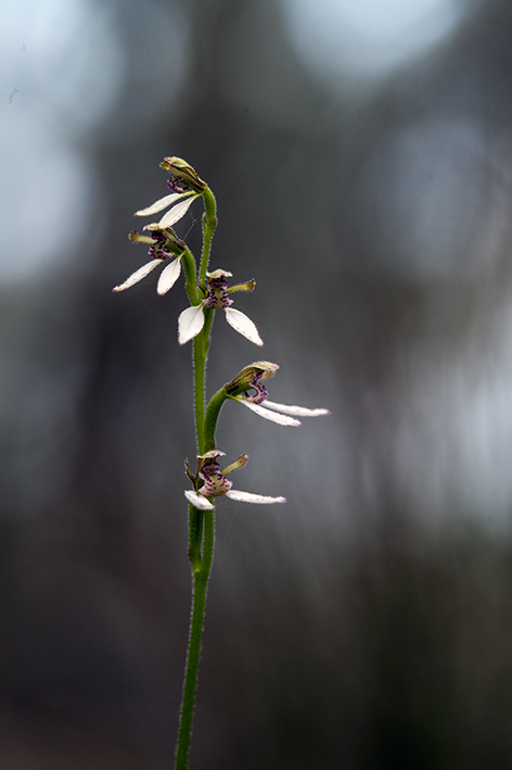
 In the thick mulch below grew autumn flowering bunny orchids.


And on the fallen branches grew these lovely lichens.


The view from the top past flowering Hakea laurina towards the bar and ocean.


According to South Coast Rivercare the Pallinup River rises in The Yilgarn Plateau south of Katanning with some salt lakes draining into the catchment in wet years. All the river is saline to some degree. The salinity has increased since clearing in the catchment region especially since the 1950's. Melaleuca cuticularis (saltwater paperbark) and Eucalyptus occidentalis (yate), are found growing here as both do well in saline conditions.

Friday, 27 July 2012

Our winters are warm

Our summer is hot
And water is precious

These words are written on the town water tank on the top of a hill overlooking Marble Bar. Marble Bar has a reputation for being hot and is surrounded by low hills in the middle of the Pilbara, I suppose it is not surprising. All that heat absorbed by the bare rocky ground and then trapped in the hills. They have a record of 160 consecutive days over 38.7C (the old 100F) from the summer of 1923-24. However we had cold nights and warm days whose maximum didn't go over 30C.

Early morning shadows on the water tank


I climbed the Water Tank Hill a couple of times. At dawn I was fascinated by the rich blue shadows on the tank cast by the early golden sunlight. The distant hills glowed orange red with deep purple shadows.

Overlooking Marble Bar town


Speaking to a Queenslander enjoying the warmth, who had plans to stay a while hunting for gold, she said the locals told her "You'll be gone by the end of August - it'll be too hot for you!" She thought she might last a bit longer than that. I know I'd certainly be hightailing it out of there before the heat set in.


Government buildings Marble Bar


Gold was found here in 1891 and the town was established in 1893. The Government building, still being used for government services was completed using local stone in 1895. It is undergoing some renovations at the moment. If you look closely at the photo the scaffolding is just visible.


Banded jasper or 'marble'


Marble Bar is named for the banded jasper which crosses the Coongan River just out of town. The reds, blacks and creamy white stripes reminded the pioneers of marble. It is quite startling where it is visible, although most of the bar was covered in a layer of dried mud when er were there. A few hardy bodies splashed in the pool of water there, but it looked a little unappealing to me, muddy and greenish.


Pippunyah solar diesel power plant - solar arrays


There is a state of the art solar diesel power station just out of town. It supplies power for both Marble Bar and Nullagine. A few stats: it saves about 223,000 litres of diesel and avoids 600 tonnes of CO2 emissions by supplying 1150mwh of  solar energy per year. Quite impressive.

Grevillea flowers


Every now and again we would come across these grevilleas in flower. The birds just love them for their nectar and there are always a variety of honeyeaters to be seen and heard near by. In the water courses the eucalypts were heavily in bud. From the top of the hill you could track the water courses by the lines of trees snaking their way through the hills.

View from Tank Hill in early morning and walker in blue


Sunday, 22 July 2012

Running Waters


View towards Running Waters


Amid all the aridity in the region of the Skull Springs Rd there are a couple of surprising green and moist oases. The most notable is Running Waters where the creek forms a big pool across the road. And the water there is running, I even recorded it's babbling and gurgling - just because I could.


Skull Springs Road


We camped the night there in the middle of the braided 'creek' high up on a berm of coarse sand, pebbles and rocks. Creamy trunks of tall trees surrounded us, both eucalypts and paperbarks.


Our campsite 


There were pools up and down the watercourse, some clear and running, others still and dusty. There were plenty of birds to be seen and heard and downstream there were ducks and grebes and a whistling kite nesting high in a tree beside the biggest pool. After dark we heard the unmistakable call of the blue winged kookaburra competing with the lowing of the cattle and hum of the crickets for airtime. In the morning as the sun's rays lit the tops of the trees, I watched a family of white-browed babblers peel off one at a time out of their big communal nest above our camp site, churring and chattering as they do.

Downstream pool


In late afternoon there was the loud thumping of blasting some distance away. Throughout the night we heard the sounds of mining vehicles and planes on the move, not surprising as there are a few mines in the vicinity, Woodie Woodie being the largest. What was surprising was the relative quietness during the day - or perhaps our other senses were more occupied in the day, thereby masking the mining sounds?

Looking up


Recently ( in the last few years) there had been a good flood, as the banks of the lower watercourse were eroded down to a spongy mat of tree roots. Flood detritus forming large mats hung high in the branches and draped around tree trunks. The lower couple of metres of paper bark had been torn from the trunks of the trees by the force of rushing water and detritus. Seeing it in the dry season, peaceful and calm, it is hard to imagine the quantity and force of water in flood times.

Miske with flood detritus above her head


Friday, 20 July 2012

There's gold in them thar hills

(and iron ore and manganese and ... )

From Punda we headed for Nullagine further inland and in the heart of gold country. Part of the road to Nullagine was being upgraded and it was very dusty, staining the roadside vegetation a rusty red. Visibility was often reduced to no more than a car's length when passing the ever present trucks servicing the mining and exploration boom. Bulldozed mining tracks criss-crossed the hills as we passed Cloud Break Mine (iron ore) and Hancock Prospecting Roy Hill project.


Dust on the Marble Bar Road to Nullagine


It is beautiful country. The ancient hills have been eroded down to stubs of orange and pinky brown, studded with creamy white. The vegetation is sparse lime grey spinifex dotted with straggly blue leaved acacia and gnarly white trunked eucalypts in the gullies that drain the hills. As we moved into the gold country the termite mounds changed from dark chocolate red to soft grey brown. 


Nullagine is a pretty spot, surrounded by low hills with big trees lining the 'river' running through town. The river sported a small pool of water lined with bulrushes on the edge of town. In the late afternoon a group of children played in the sand heaps beside the caravan park, sliding down the slopes on scraps of wood and tin. I remember doing the same when I was a child.

Contorted tree on the Skull Springs Road


We met a prospector there who had been out with his metal detector on the hunt for gold. Him - "you out looking for gold?" Us - "no, we've got a detector here 'cause someone said it'd be a good idea, but we haven't taken it out of its box." Him - "Oh, so you're here for the scenics? ... do you want to see what I found?"

Prospector on the Skull Creek Road


He reached into the deep recesses in his 4wd and pulled out an old 35mm plastic film container, tipping out some minute flakes of gold  - "That's about two hundred dollars worth there ... just a day's work. I've been checking out some spots. I'm taking a party of prospectors out in a couple of weeks and they need to find something - to keep them happy - otherwise I'll be out of work."


Low hills with acacia on the Skull Springs Road


I couldn't imagine trolling up and down over the ground for hours listening for the golden beeps from a metal detector. But there is always the lure of that 'big find' that gets people excited. Later on in Marble Bar we met a couple who had spent the last ten days "wandering aimlessly up and down" for five hours a day each. They showed us a nugget of just over one ounce that they had found. A bit more impressive I must admit - but it took about a hundred hours of trolling to find it. I think I'll stick to the 'scenics'.

Rocky outcrops


Travelling along the Skull Springs Rd out of Nullagine the road negotiated a series of steep gullies draining the low hills. The road was closed to vehicles over four tonnes, I expect due to the sharpness of the dips. Further east we took a detour down to the Woodie Woodie manganese mine. Here were huge stockpiles of mine spoil with giant trucks traversing the top of the spoil heaps, dwarfed by their surroundings. As a reminder that this is station country, there were cattle grazing at the foot of the heaps.

Cattle feeding below one of the Woodie Woodie spoil heaps


Along sections of the road where the traffic rate is high, and especially on unfenced sections, there is an ever present parade of cattle carcasses in various states of decomposition. Once we came across the poignant scene of a cow standing beside her now dead calf, not yet ready to leave. The only good to come from these deaths is the feast it provides for the crows and wedge tailed eagles. It is a common sight for them to be sharing the repast.

Australian bustards


Just out of  Woodie Woodie we came across this pair of bustards crossing the road. Mark took this photo as they headed into the spinifex. Australian bustards grow up to 1.2m high and can weigh in at 14kg with a wingspan of up to two metres. I must admit I have never seen them fly. Their habitat of choice is tussock grassland adjoining some denser vegetation to provide some protection for the single egg they lay on the ground. It is always a thrill to see them. They are not as common as they used to be and their range has reduced as well.


Sunday, 8 July 2012

Pilbara rivers and watercourses

One of the things one does when travelling up here is skip from watercourse to watercourse, and pool to pool. The rivers rarely run except after rains, and consist of a collection of waterholes between lengths of dry riverbed. The surrounding countryside is fairly arid in comparison to the lush greenery around the water.

Just before Newman we had lunch at the south branch of the Gascoyne River. It is a pretty spot, a small still pool of water, slim paperbark trees with silky foliage and shady white trunked eucalypts following the winding course of the river. While Mark tried to photograph a whistling kite stalking the flocks of birds coming in to drink, Miske and I walked downstream to see what we would see. I came across this wonderful twisted tree branch.

Gascoyne River view, south branch


After Newman we drove out to Kalgan Pool, for which we had to get a permit from the tourist bureau in Newman to use a short section of the BHP road. Kalgan Pool is a popular spot with the locals, being so close to town. The road in is normal 4wd. There were a couple of other campers there while we were there. The main pool is at the base of a large red rockface, lined and contorted, and there are a series of other pools within easy walking distance along the watercourse. I explored a few gullies and clambered up part of the side of the gorge overlooking the pool and campsite. It was beautifully warm in the early morning sunshine, while the camp was still in deep shade and very chilly. Softer grasses grew in the gullies - lemon grass and wallaby grass while spiky spinifex grows higher up. Miske soon learnt to tread carefully once we left the gullies. The flowers of Wickham's grevillea and eucalpyts were busy with little honeyeaters.

View from side of gorge, our camp is down there

Miske beside Kalgan Pool in the morning


There were some lovely acacia's with minni ritchie bark growing in the first gully I walked up. I love it with the sun shining behind it, highlighting the curls.

Minni ritchie bark

We passed the galahs on our way in, feeding beside the railway line. The background is typical of the country surrounding the watercourses.


Pink and grey galahs


Wednesday, 4 July 2012

Bits and pieces near Newman

In travelling up north one spends a lot of time driving. The landscape is largely viewed from one's vehicle with the regular stops for fuel and camping at selected points of interest.

Refuelling at Meekatharra


Newman is largely a mining town. Accommodation units abound. We stayed at Kalgan's Rest which has a small section in the middle for travellers like us. The periphery is devoted to mine workers with one and two story dongas. Around sunrise and sunset one hears the 'crunch ... crunch ... crunch' of the workers footsteps on gravel as they head off for work and a little later the 'crunch ... crunch ... crunch' as the alternate shift workers return. On the streets the mine buses can be seen picking up and ferrying the workers. The dress of choice is fluoro orange and yellow vests, and four wheel drive vehicles sporting a legion of mine insignia, and safety features.

Corellas at Newman

The other thing that caught my eye were the muddy brown little corellas. They were busy feeding in the mown grass, drinking from puddles and playing high on the street lighting.

Just out of Newman near the Opthalmia Dam turnoff we came across another of the hills being eaten away by mines. This time we stopped to photograph it. It is a weird sight - half hill, half mine. 


Mine just of Newman

Friday, 29 June 2012

The road to Newman

We have arrived in Newman in the Pilbara and I will give you a glimpse of the trip up here. For those who don't know Newman is 1186km from Perth and is in the heart mining.


Trucks: our car looking out


Once past Wubin, the road up north belongs to road trains. Wubin is on the interface between cropping country and station country, uncleared grazing land. The road trains are feeding the mining boom up north carrying all sorts of weird and wonderful payloads from food to ammonium nitrate to tankers of oil to
enormous pipes, concrete structures, one caterpillar track weighing 60 tonnes and tyres which are so wide they have pilot vehicles flashing before and after. Whole hillsides are being carved away in the production of metals like gold and tracks disappear off the highway chasing precious metals. Near White Wells they were cutting awaya hill with matchbox sized machinery, flashing lights and meccano set steel structures. The size is deceptive, the machinery is actually huge making the hillsides appear small until you see the drivers tiny cab perched up high. In stark contrast, we passed a big pond of water near the Ningham turnoff with a battalion of lovely black tailed native hens feeding in the shallows. They strutted off into deeper water as we drove past, their tails held high.


Main street Mt Magnet

We camped out of Mt Magnet at the Amphitheatre, in breakaway country


Breakaway with quartz base


It is ancient sedimentary red rock, worn and hollowed, with white quartz scattered on the lower slopes. Visitors to this spot had put the quartz rocks to good use, leaving messages on the flats between the outcrops. Scattered sage grey mulgas are the dominant vegetation, a few earl golden flowers wafting their heady scenton the breeze. Goats abound keeping the lower vegetation heavily grazed.


In the early morning a flock of little woodswallows swooped up and dived from rockface to sky and down to cluster in a rock hollow only to swoop up into the sky again, stretching their wings after a night of slumber.

Little woodswallows

While out walking I heard the distinctive call of the red capped robin, a strong 'tchek...tchek', but only saw the female. We came across a party of white-browed babblers which also are distinctive with their churring and wheezing chatter as they forage in family groups close to the ground. They always sound like they are having fun following one another in the shrubbery along inland watercourses (waterless usually of course).

The Amphitheatre: our car is the white dot in the middle distance

Gold was found at Mt Magnet in 1891 by George Woodley which initiated white settlement in this area. Aboriginal use of this area goes back thousands of years. The Hill 50 Gold Mine 'Harmony' operation is visible from the Warramboo Lookout. This mine is a large open cut with underground workings as well. The Checkers Gold Mill was completed in 1989 and milled it's millionth ounce in 1997. It is still operating.

Hill 50 Gold mine 'Harmony' in distance

Monday, 18 June 2012

On the move

Now that we've had some good winter rains, huge flocks of birds are patrolling the farm paddocks feasting on the plentiful food to be found. There have been a few white ibis around here for some time but in the last week flocks of straw necked ibis with their glossy iridescent black wings have been seen wheeling through the sky in 'V' formation then landing and working the paddocks for insects. They will be seen feeding in the paddocks for months from now, going well into spring. I must admit I don't know where the ibis go to when they disappear later in the year.


Part of a flock of straw necked ibis

Another fantastic sight is the black swans feeding in paddocks. Previously we'd see them in selected spots on the inlet, their long necks curving down into the water as they fed on underwater vegetation. Their beautiful bright red beaks a rich contrast against their black plumage. Now they flaunt themselves in the paddocks, occasionally stretching their wings to reveal the stark white wing flash. Going past the inlet today there were only a few swans to be seen on the silvery waters.


Black swans feeding 

The black swan, Cygnus atratus,  is the only swan in the world that is predominantly black. I am so glad they are still plentiful. To me they have always seemed special. A few years ago we were camped at an inland lake that had a number of swans making the most of the plentiful water. All night long we heard the magical sound of the swans - a surround sound of musical bugling as they called to each other across the lake. All the more beautiful when you are out in the desert - so unexpected.


Black swans clearly showing their red beaks

Cattle are the most commonly seen animal in the paddocks around here. These are fairly late calves as calving generally starts in late summer. Mostly it's beef cattle with a few hardy/efficient/enterprising dairy farms still operating in this region. There has been a gradual change from dairy to beef cattle farming in this district. We live on what was once a cattle farm - subdivision for housing is now more lucrative than farming especially close to town.


Calves under the karri

Couldn't resist this - mobs of roos are quite a common sight in paddocks too - they are here all year round sharing the paddocks with the cattle and the birds.


Small mob of roos with peppermint trees behind

Just as the birds migrate from one area to another so to do the humans. Winter is a time when a portion of the population down here head up north to the warmer weather. We will be doing the same, heading north during my uni break till we hit the warmer weather. Next weekend we are heading up to the Pilbara for a month. So I will be posting from whenever I can manage it - access to communications and power permitting. The towns will be fine but when we are camped out in the sticks - ?? I'll find out.